
A geothermal transect in the Western US
Time is flying and another leg of my journey is now complete. I think the past 4 weeks in the central-western US have been the busiest so far, packed full of meetings, conferences, tours, and field trips. My brain is feeling pretty saturated, and hopefully there is some room for more knowledge in Germany, my next destination.
The United States produces the most geothermal electricity in the world, and the majority of the resources are in the states of California, Nevada, and Utah. Minor resources are also found in Washington, Oregon, and Idaho. The abundance of geothermal resources in this part of the world is largely due to combination of young volcanism and active faulting; there is plenty of heat in the shallow crust, and plenty of permeability to allow groundwater to heat up.
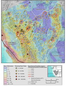 Image: Geothermal systems and regional tectonic setting of the central-western United States. The Basin and Range geologic province is characterized by north-south trending horsts (ranges) and grabens (basins). The majority of dextral shear strain between the Pacific and North American plates is accommodated on or near the San Andreas fault, with a minor component on the Eastern California Shear Zone and Walker Lane. Note that Nevada hosts the greatest number of geothermal power plants, but the largest power producers are in California. Source: Faulds and Hinz (2015).

My visit began in Reno, NV, which is probably known more widely for its casinos than its geothermal resources. However, it is actually one of the major centers of geothermal exploration in the US. Situated on the eastern flank of the lofty Sierra Nevada, the city itself sits in a fault controlled valley that is part of the Walker Lane shear zone. This NW-SE-striking shear zone takes up roughly 20% of the right-lateral shear strain between the Pacific and North American plates, the remainder of which is mostly accommodated by the San Andreas fault. Moving east of Reno, the dextral transtension of the Walker Lane transitions to pure extension in the Basin and Range geologic province. This is an area characterized by north-south trending ridges (horsts) and valleys (grabens). The horsts typically have a normal fault on one or both of their flanks, and many are host to regular seismicity.
The geothermal resources in the Basin and Range are considered “amagmatic”, meaning that there is no shallow magma body providing heat. Instead, because of the active extension, the earth’s crust is quite thin, and the geothermal gradient and heat flow are consequently high. The active faulting provides abundant permeable pathways for fluid to percolate downwards, and it doesn’t have to go far before it passes the boiling point.
I spent the first few days of my visit with researchers at the Great Basin Center for Geothermal Energy, a branch of the Nevada Bureau of Mines and Geology, situated on the University of Nevada, Reno, campus. This visit was of special interest to me because of the work done at the GBCGE on amagmatic, fault hosted geothermal resources, which are in some ways analogous to my field area in southeastern British Columbia.
Favourable Structural Settings
Nevada is a great place to do structural geology. Unlike the lush forests of British Columbia, the dry climate and sparse vegetation do not act to obscure structural features in the landscape. Because of ongoing extension, many of these faults still have conspicuous scarps that betray their exact location, which makes them mappable for many kilometers along strike. The abundance of structural data has allowed researchers at the GBCGE to identify the most favourable structural settings for geothermal resources, i.e., those locations that have the highest permeability. It turns out that zones of high structural complexity and localized extension seem to host the greatest number of known geothermal systems in Nevada. I hope to identify similar localities in my own study area.
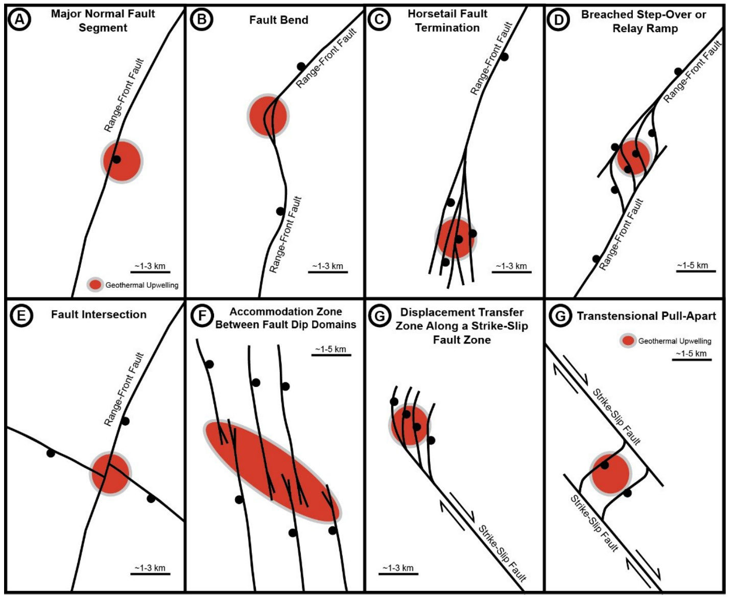
Image: Favourable structural settings for hydrothermal systems in Nevada. The highest percentage of geothermal systems in Nevada occur on fault terminations (C), fault step-overs (D), and fault intersections (E). Source: Faulds and Hinz (2015).
Play-Fairway Analysis
Researchers at the GBCGE have developed an geothermal exploration method dubbed “Play-Fairway” analysis. This is a term borrowed from the oil industry, and it essentially refers to a regional statistical assessment of a number of factors that might control the presence or absence of a resource, including heat flow, fault activity, crustal stress, and the orientation of faults. The key of course, is assigning a proper weight to each parameter such that the map you produce is actually useful; put too much weight on a single parameter, and you might end up with a bunch of false negatives and positives. The method is calibrated by comparing the results to previously known geothermal system, as well as ground-truthing the predictions through ground temperature measurements.
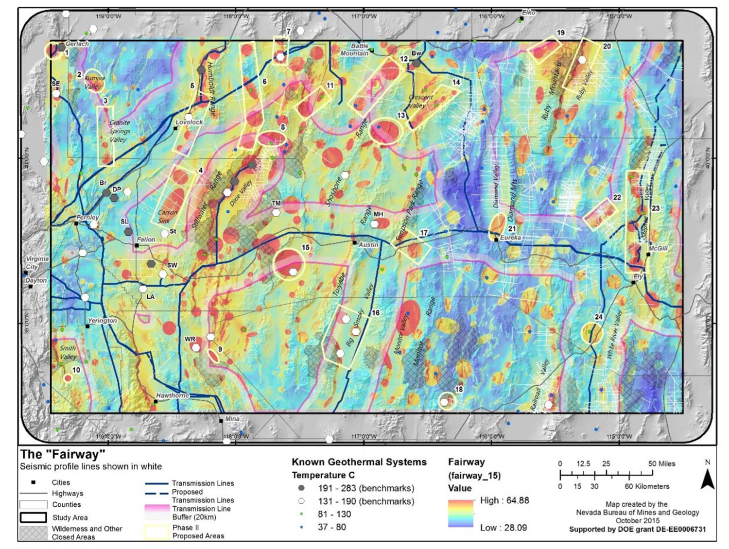
Image: Final product of the Play-Fairway analysis of the Great Basin. Most favourable areas for new geothermal development are highlighted in bright red, based on a statistical analysis of numerous layers of of data. Source: Faulds et al., 2016.
Blind geothermal systems and Gabbs Valley
Interestingly, the assessment of structural settings and Play-Fairway analysis has pointed to regions in Nevada that did not previously appear to host geothermal systems. These are known as “blind” geothermal gystems, because there is no surface manifestation (e.g., hot spring, fumarole) to indicate their presence. There are a few reasons these systems are hidden, including a low, cold water table that blocks hot water upflows from reaching the surface, and/or a permeable upper layer of sediment that might cause hot upflows to diffuse before reaching the surface. It is estimated that ~75% of geothermal systems in Nevada are “blind”, which makes approaches like Play-Fairway very powerful.
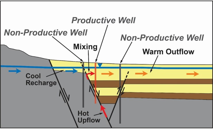
Image: Conceptual model of a blind geothermal system. Note how the cool recharge suppresses any surface manifestation of the hydrothermal system. Source: Richards and Blackwell (2002)
A great example of a blind geothermal system is found in Gabbs Valley, to the east of Reno, on the western boundary of the Walker Lane shear zone. Structural mapping and Play Fairway analysis predicted that this area might host a geothermal system, and an array of shallow (2 m) temperature probes confirmed a positive temperature anomaly right at the intersection of a dextral fault and a normal fault, i.e., a zone of local extension and structural complexity. A more comprehensive temperature gradient hole drilling program was completed this past summer, and temperatures of 152°C water within 117 m of the surface! Perhaps there will be a new power plant here in the future.
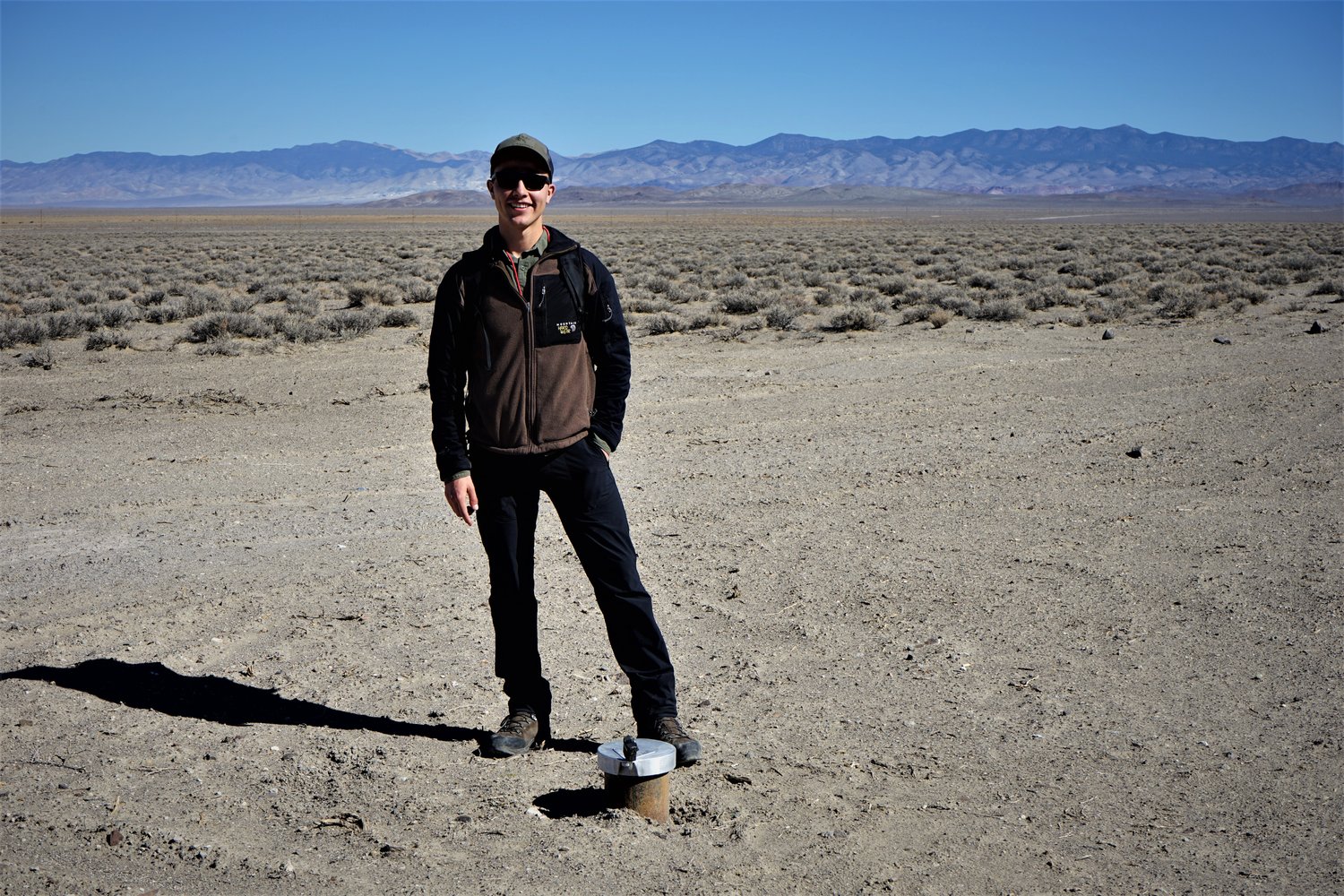
Image: A temperature gradient hole well head in Gabbs Valley. You wouldn’t know it from the surface, but 117 m down this well, water temperatures reach 152 C!
Geothermal Resources Council Meeting
My visit to Reno also coincided with the annual meeting of the Geothermal Resources Council. This conference brings people from all parts of the geothermal industry together, including geoscientists, drillers, engineers, and entrepreneurs. It was a busy few days with many, many interesting talks on geothermal projects occurring around the world. It would be impossible to summarize all of the talks and conversations here, but suffice to say, my eyes were widened. It seemed to me that one of the major focuses of the conference was on Enhanced Geothermal Systems, and the complex reservoir engineering required to make them a reality… more on them below. The conference was held at the Peppermill Resort and Casino, chosen in part because it actually gets all of its heat from geothermal wells drilled on the property! The project came at a cost of $9.7 million, but with annual savings of $2.2 million previously spent on natural gas, the return on investment was fast!
Long Valley Caldera
As part of the Geothermal Resources Council meeting, I participated in a 3-day field trip to the Long Valley Caldera in central-eastern California. The Long Valley Caldera, once home to a massive eruption second only to Yellowstone, has a complex volcanic and tectonic history, spanning the last 4 million years. The caldera itself, which covers roughly 500km2, formed around 770,000 years ago with the eruption of the famous Bishop Tuff. It sits in a right-stepover between the right-lateral Eastern California Shear Zone and Walker Lane, resulting in localized crustal extension that probably controls both the volcanism and hydrothermal systems. Geothermal exploration has occurred here since the 1960s, and one power plant produces ~40 MW. Initial exploration focussed on the center of the caldera, under the assumption that the source of the heat would be at the center of the volcanism. More recent investigations have shown that the main source of hot water comes up along the southwestern edge of the caldera, and is likely fault-controlled (surprise!).
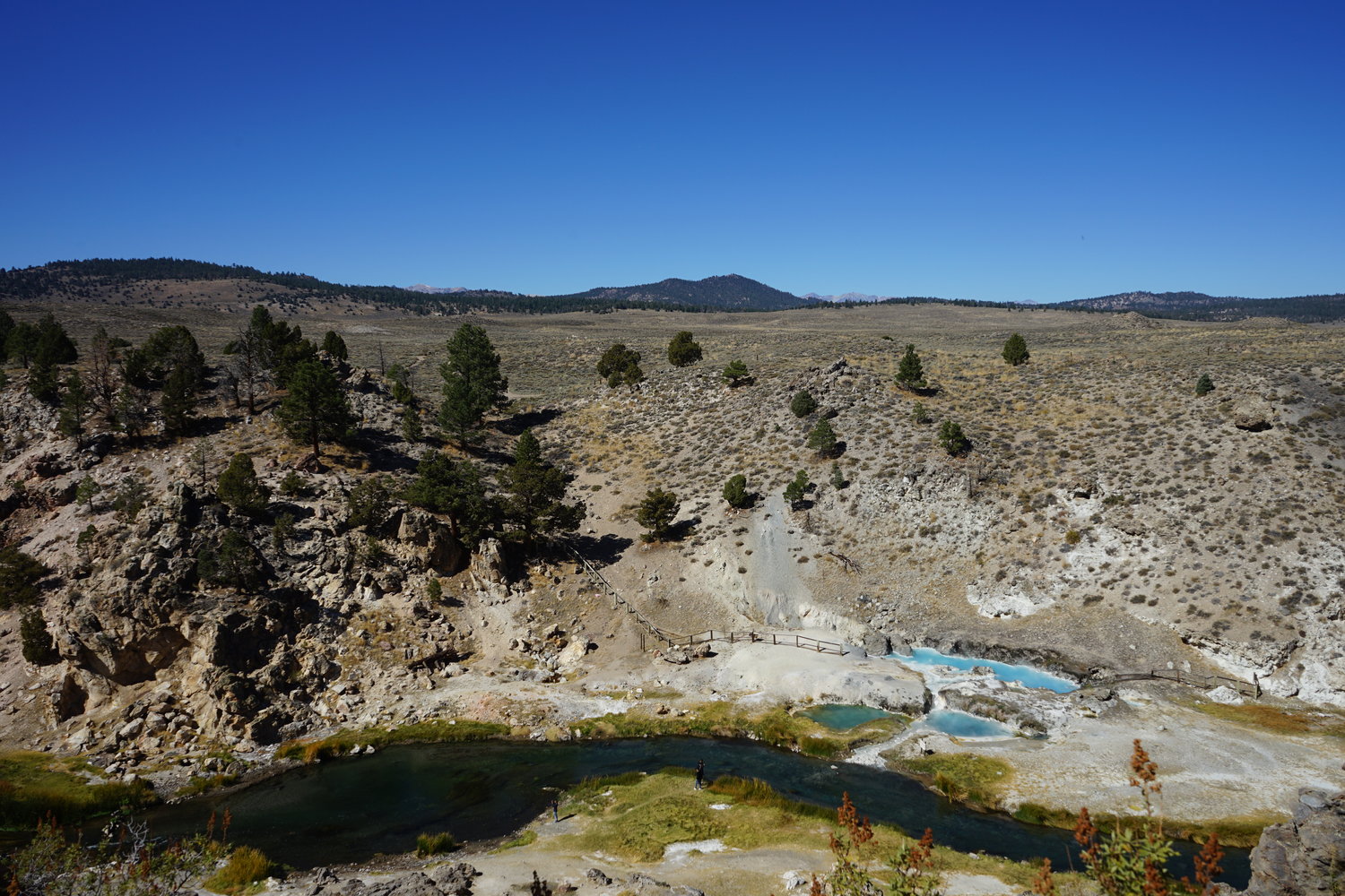
Image: Hot Creek thermal springs in the Long Valley Caldera. The gap in solid bedrock outcrop on the far stream bank corresponds to a fault zone, in which damaged rocks are more susceptible to weathering. The spring, which appear to emanate from this fault zone, has fluctuated in temperature and flow rate over the years due to volcanic unrest. Don’t go swimming in this one unless you want to end up like that couple in Dante’s Peak!
Salt Lake City and the Wasatch Front
I then took the Amtrak train from Reno east to Salt Lake City and was treated to a stunning sunset in the desert, passing basin after range, horst after graben. I think I’ll take the train every change I get from now on! I woke up in Salt Lake City and took the weekend to explore the area. Salt Lake City and the adjacent urban areas are collectively known as the Wasatch Front, as they are located along the north-trending Wasatch Range, which is controlled by the Wasatch Normal Fault on its western flank. This is an active fault and is due for a rupture in the near future. There are several thermal springs along the Wasatch Front, and these seem to occur in association with deviations (aka salients) in the strike of the fault, possibly because of high structural complexity and permeability at these locations.
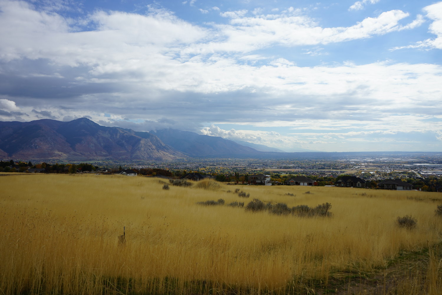
Image: Looking south along the Wasatch Front. An active normal fault at the base of the Wasatch Mountains drops the west (right) side down every ~350 years. The segments of the fault near major population centers like Salt Lake City are considered overdue for another earthquake. Thermal springs seem to occur in conjunction with bends in the Wasatch Fault, where there is perhaps more structural complexity and permeability.
The Milford FORGE Site and EGS
Many consider the future of geothermal energy to lie in Enhanced or Engineered Geothermal Systems (EGS). There is heat to be found in earth’s crust all around the world, but the trick is finding heat within shallow enough depths, and with enough permeability to allow water to circulate. Lack of permeability truly restricts wide adoption of geothermal energy. The idea behind EGS is to create the necessary permeability by way of hydraulic fracking or shearing, i.e., pressurized injection of water in order to cause fractures to open or slip.
While promising in theory, EGS projects have had limited success. In an attempt to stimulate research on the topic, the US Department of Energy has funded a program known as the Frontier Observatory for Geothermal Energy (FORGE). Groups in Idaho, Washington, Idaho, and Nevada competed for the final funding, and ultimately Utah was selected. My visit to Salt Lake was hosted by the Energy and Geoscience Institute at the University of Utah, who lead the charge on the FORGE project in Utah. I was fortunate to have the opportunity to visit the future site of the FORGE site near the town of Milford. It is situated near an existing geothermal power plant, and the wells from this plant were instrumental in understanding the hydrogeology of the area.
Two full size wells will be drilled into an impermeable granite pluton in the subsurface. One or both will be used to stimulate the reservoir, by injecting water at several intervals along the borehole in hopes of creating connected pathways between the wells. The trick is getting the fracture size and density just right so that water can pass through fast enough to maintain flow, but slow enough to pick up sufficient heat from the surrounding rock. If fracking is successful, water will be injected into the lower well, from which it will flow upwards due to buoyancy, and exit via the upper well, at that point hopefully hot enough to generate electricity. The success of this project will probably be hugely influential in the future of EGS, so this is certainly one to watch.
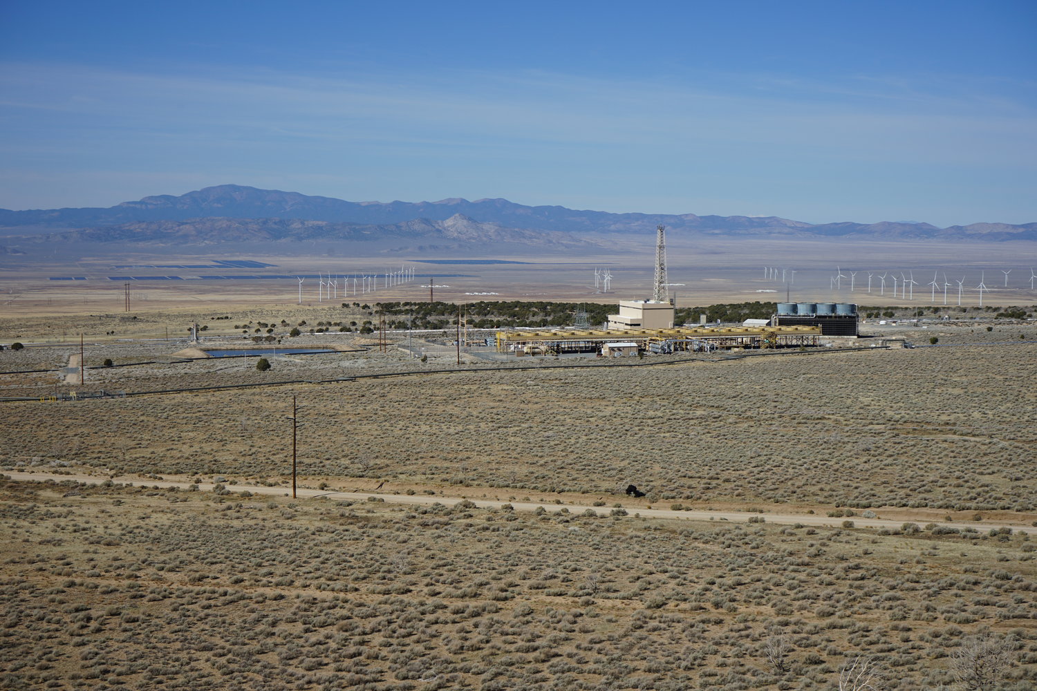
Image: The Milford Renewable Energy Corridor, looking WNW. In the foreground, the Blundell Geothermal Power Plant produces 34 MW of power from a hydrothermal system that appears to be bounded by a steep fault that roughly corresponds to the treed hillside behind the plant. The Milford FORGE site will be between the rows of wind turbines on the right side of the image. Across the valley, a large solar farm also produces electricity.
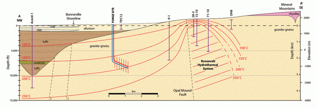
Image: Cross-section of the Milford FORGE site. The previous photo looking across the valley was taken near the OH8 well on the right. Production and injection wells will be drilled into a large granite body at a depth of approx 3000 m. Note on the SE side of the Opal Mound Fault, an active hydrothermal system is currently used for power production. The FORGE wells will not take advantage of this system because the intention is to create a new system in impermeable rock. Source: Utah Geological Survey.
Homestead Crater
On my last day in SLC, we visited Homestead Crater, near Park City up in the mountains. At first glance this tourist destination is simply a mound of travertine (carbonate), but when you climb to the top, you can peer down a hole into the hollow center filled with warm water. A shaft has been tunneled into the side of the crater, and a local lodge runs SCUBA courses in the cavern. The question is: why is the travertine mound hollow, and why is the water level only halfway up the inside? It seems that this phenomena might provide insight into the paleohydrogeology of the region. The head (level of the water table) must have been higher at the spring outlet in the past in order to construct the full height of the travertine mound. At some point the spring water must have become undersaturated in carbonate, leading to the dissolution and hollowing-out of the crater.
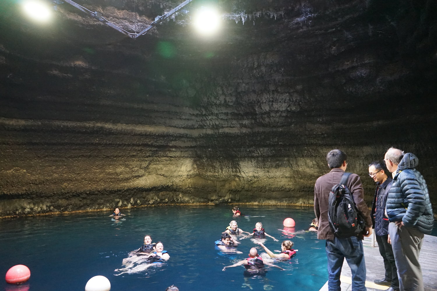
Image: The Homestead Crater, a dome of travertine with a deep pool of warm water inside.
California and the Geysers
The last stop was Berkeley, California. My primary destination was the Lawrence Berkeley National Lab, which is home to a geothermal research group. The Bay Area is also home to a number of geothermal consulting companies, and was fortunate enough to have informative meetings with geoscientists at Geologica, GeothermEx, and ThermoChem, about the work they do, and which techniques they find most useful in geothermal exploration.
One of the highlights of my visit was a tour of the massive Geysers geothermal field near Santa Rose, California. Situated about 2 hours north of Berkeley, this is the largest geothermal field in the world. Over 300 wells collect steam over an area of approximately 115 km2, producing around 735 MW, or power enough for 735,000 homes! The geothermal potential of the Geysers was first identified back in the early 1900s, but it wasn’t fully developed until the 1970s. At that time, very little was known about reservoir sustainability, and steam was extracted at an enormous rate, producing upwards of 2000 MW! Eventually it became apparent that the field was in decline, as too much heat and pressure was being removed. A win-win solution was reached with local communities who were looking for somewhere to dispose of their treated waste water, which could not be put back in local creeks; water from Santa Rosa and Lake County was pumped up to the Geysers and injected into the wells. Since the beginning of this program, the production at the Geysers has stabilized.
The heat source of the Geysers is believed to be a ~1 million year old felsic intrusion about 1000 m below the surface, as well as some possible smaller younger intrusions. These intrusions are still young enough that they have residual heat, rather than radioactive heat like the plutons in Alaska. This region is also heavily influenced by the transform motion between the pacific Plate and the North America plate. While the San Andreas fault takes up most of this strain, a portion is distributed among smaller parallel faults, a few of which run through the Geysers field.
While the major faults in the Geysers area are easily identified with surficial mineral deposits and topographic manifestations (i.e., linear valleys), many smaller faults have only recently been identified using 3D mapping of micro-seismicity. The continuous extraction and reinjection of fluids into the subsurface induces many small earthquakes beneath the Geysers area. These are monitored closely with a dense network of seismometers. When their precise locations are plotted in three dimensions, distinct fault planes are illuminated. The team at the Geysers takes public outreach very seriously, and are very transparent with their operations and the resulting seismicity. As a result, local communities are very supportive and trustworthy of their operations, despite the occasional microseismic events. This is certainly a model future geothermal projects should follow!

Image: One of the many power plants at the Geysers geothermal field, the world’s largest geothermal power producer. In the background, numerous steam pipes from various wells are visible.
I’d better end this blog (novel) here because it’s getting way too long. My sincere thanks go to everyone who hosted me during my transect of Utah, Nevada, and California!